Skip to main content.
Wodonga Weather
Moderate drizzle 13.3
Wodonga
Updated: 9/6/2026 3:30 PM
Temperature
Now:13.3 (55.9)
-1.2 /hr
Cond.:Moderate drizzle,
High:
15.2 @ 2:00 PM
Low:
5.3 @ 12:24 AM
Feels like:
14.1 °C
Humidity
Current: 87 %
High:
96% @ 8:13 AM
Low:
79% @ 1:46 PM
Dew point:
11.2
Pressure
Current: 1024.1
-1.3m
High:
1028.3 @ 12:16 AM
Low:
1023.7 @ 2:42 PM
Wind
Current: 0.0 SE
Gust: 0.0 SE
Max: 8.0 ESE
(Max: 8.0 kmh)
Rain:
Today: 3.6 @ 3:26 PM
Yest: 0.2
Month: 44.8
Year: 325.0
Sun
Rise: 7:19 am
Set: 5:04 pm
Moon
Rise: 1:20 am
Set: 12:40 pm
Links
Weather Display Web site
Weather Display Web site
Other data
Max gust last 7 days: 25.9 kts, on Wed
Max temp last 7 days: 16.1 °C, on Sat
Min temp last 7 days: 5.2 °C, on Mon
Diff in av temp last 24 hrs: 1.0 °C
Wettest curr month on record: 108.4mm 2021
Driest curr month on record: 0.0mm 2015
Validation
This page is XHTML 1.0 compliant. Validate the
XHTML
and
CSS
of this page.
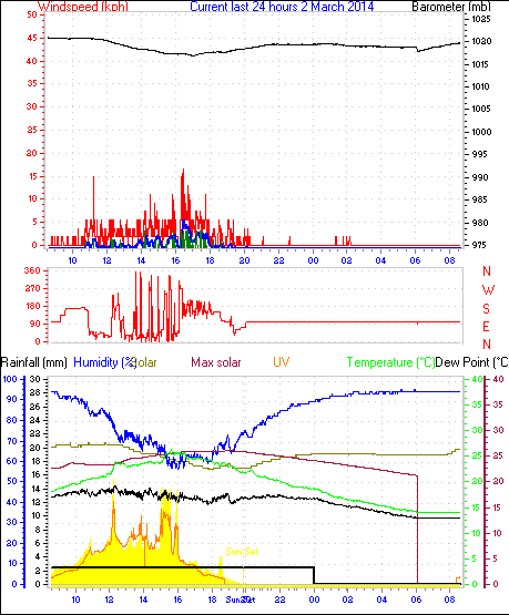
Last 24 Hours
Auto Scale graphs